


Parade Staging Instructions & Road Closures
The Bel Air July 4th Parade is staged on S. Main Street/Emmorton Road (Route 924), Idlewild Street, and on the access roads in the Bel Air Middle School and Homestead-Wakefield Elementary School complex.
If you have applied and have been ACCEPTED into the 2023 Parade, your staging instructions are e-mailed to you on or about June 22, 2023. If you have not received or seen these by June 25, 2023, send an e-mail to the Parade Committee immediately.
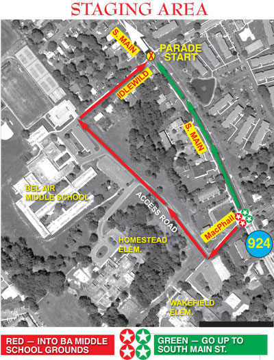
All parade units MUST ENTER THE PARADE STAGING AREA at the intersection of Emmorton Road (Rte. 924) and MacPhail Road — the "4-Star Intersection" (as it is on the map). The staging area opens at 4 pm (1600 hours); please do not arrive before that time!
All units are sent identification as to whether each is a GREEN UNIT or a RED UNIT. As per the map, GREEN UNITS proceed north on S. Main Street; RED UNITS go into the school complex.
Parade Marshals check in each unit and direct it to its proper place. Although the parade STARTS at Idlewild and S. Main, ALL motorized units (cars, trucks, trailers, etc.) must enter the staging area at MacPhail and S. Main/Emmorton Road. There are no exceptions! You should be in place no later than 5 pm (1700 hours) in order to assure that you are in the proper order and ready to deploy.
2023 Parade Staging MAPs
These maps, in PDF format, may be downloaded for use by Parade Units and their participants.
Approaches to the Staging Area.
Close-up Parade Staging Area Map in General, including Parking Lot designations. All units are either RED or GREEN, and individual sub-division assignments are handled by the Parade Marshals.
Map for COLOR GUARDs or other units at the FRONT of the parade.
Parade DISPERSAL AREA Map (General). Note: Some units have specific, different dispersal protocols, and even dispersal routes. If you have any question about dispersal, send an e-mail to the Parade Committee.
Vehicle passes are only disseminated directly to units via e-mail. Not all sets of instructions are included here.
If you have any question about this, or need additional instructions or forms or passes, send an e-mail to the Parade Committee.
ROAD CLOSURES in Bel Air on July 4
Staging and deploying a large parade, followed by a fireworks display, necessarily causes disruption of regular traffic flow through the Town of Bel Air and even in the surrounding area.
If you plan to drive through town on July 4, it may well be necessary to plan an ALTERNATE ROUTE. Here is a map showing the entire Parade Route and the 2023 road closures and suggesting alternate routes to take to avoid the downtown area.